Wildcat Creek Fall 2018 Field Results

Our great volunteers went out even through some rain to test the Wildcat Creek Watershed on September 14, 2018. Here are the results!

Sampling Results

Map of the watershed with temperature readings represented in color.

Temperature – Samplers measured temperature in the field directly from the stream at the time of sample collection. Temperature is an important parameter as it is the regulator for aquatic communities – all plankton, bug, and fish species have a preferred temperature. Temperature also controls the amount of dissolved oxygen present in the water – cooler water temperatures hold more dissolved oxygen. Finally, temperature controls the rate at which chemical reactions occur, such as the conversion of nitrate-nitrogen to ammonia-nitrogen. Higher temperatures are shown in red and cooler temperatures are shown in blue. Several factors affect temperature including riparian buffers or shading, watershed inputs, and surrounding land uses. 

Map of the watershed with pH readings represented in color.

pH – Samplers measured pH from water samples at the staging location. Water pH is a measure of the volume of hydrogen ion available in the water. Water pH determines the solubility and biological availability of chemicals, including nutrients such as nitrogen and phosphorus, and metals, like copper or lead. Typical pH levels in streams measure between 6.5 and 8.5. pH levels are indicative of the geological materials in the drainage area. Additionally, the amount of photosynthesis occurring in the stream can affect pH levels. Higher pH levels are shown in red, while lower pH levels are displayed in yellow and ideal pH levels are shown in green.

Map of the watershed with transparency readings represented by color.

Transparency – Samplers measured water transparency using transparency tubes. Water transparency in streams reflects the distance downstream that you can see through the water. Tubes measured 120centimeters, so any values greater than 120 centimeters exceed our ability to detect a change in water transparency. Low numbers (10 cm) indicate poor transparency while those in the 70 centimeter (2 foot) range indicate good transparency.  When stormwater runs across the land, it collects sediment – when this sediment reaches the river, transparency declines and light does not travel through the water as well.

Map of the watershed with turbidity readings represented by color.

Turbidity – Water samples were sent to a laboratory to be analyzed for turbidity. Turbidity is a measure of the relative clarity of water and is related to transparency.  The more suspended particles in a water sample, the more light scatters as it travels through the water and the higher the turbidity reading.  Low numbers indicate low turbidity (good) while high values indicate very turbid water and poor water quality.  Particulate matter that is suspended in streams will effect light penetration and ecological productivity in that aquatic environment.

Map of the watershed with field-measured orthophosphate readings represented by color.

Map of the watershed with lab-measured orthophosphate readings represented by color.

Orthophosphate – Phosphorus is typically the nutrient which limits the productivity in aquatic communities. Phosphorus can be measured in many forms including orthophosphate or soluble reactive phosphorus. This form of phosphorus is the soluble, organic, readily available form of phosphorus. Higher phosphorus concentrations typically lead to higher levels of productivity. Increased productivity can result in increased concentrations of algae or plants, which can result in decreased dissolved oxygen concentrations, taste and odor problems, and create poor habitat for aquatic communities.  Orthophosphate was measured in the field by volunteers using test strips, and in the lab using more precise methods. 

Map of the watershed with field-measured N+N readings represented by color.

Map of the watershed with lab-measured N+N readings represented by color.

Nitrate+Nitrite – Nitrate-nitrogen and nitrite-nitrogen, represent the available nitrogen in an aquatic system. Nitrogen is also available in the atmosphere and can move from the air into the water by nitrogen-fixers. Nitrogen can readily convert between different forms, especially nitrate and nitrite. Conversion to and from ammonia also occurs when dissolved oxygen is available in the system. Nitrate and nitrite concentrations are displayed below with red representing higher concentrations. Nitrate-nitrogen concentrations measuring higher than 2 ppm can inhibit aquatic communities. Concentrations higher than 10 ppm violate the state water quality standards.  Just like orthophosphate, Nitrate+Nitrite readings were taken in the field using transparency strips, and the water samples were analyzed in the lab using more precise techniques.

Map of the watershed with chlorophyll A readings represented by color.

Clorophyll A – Chlorophyll A is a photosynthesizing pigment found in plants and is an indicator of algae abundance and productivity.  High concentrations typically indicate poor water quality due to high nutrient concentrations.  Rainwater runoff from farms and turf grass carry fertilizers in to streams, and this fertilizer can cause an algae population explosion, also known as an algal bloom.  Too much algae in an aquatic ecosystem can decrease oxygen levels in the water and release toxins in the water that can be harmful to humans and other life forms.

Map of the watershed with ammonia readings represented by color.

Ammonia – Ammonia is present in streams as a dissolved form of nitrogen that is readily available for use by algae. At a high temperature and pH, higher concentrations of ammonia are present and can become toxic to stream biota. Similar to nitrogen and phosphorus, excessive amounts of ammonia can cause algae blooms and eventually deplete the water’s dissolved oxygen content causing hypoxia. Sources of ammonia in streams can be attributed to a variety of inputs, including: fertilizers, mammal waste, and industrial manufacturing runoff. Ammonia is not a nutrient that can easily be tested for in the field, so ammonia testing is done at the water quality lab.

Map of the watershed with E. coli readings represented by color.

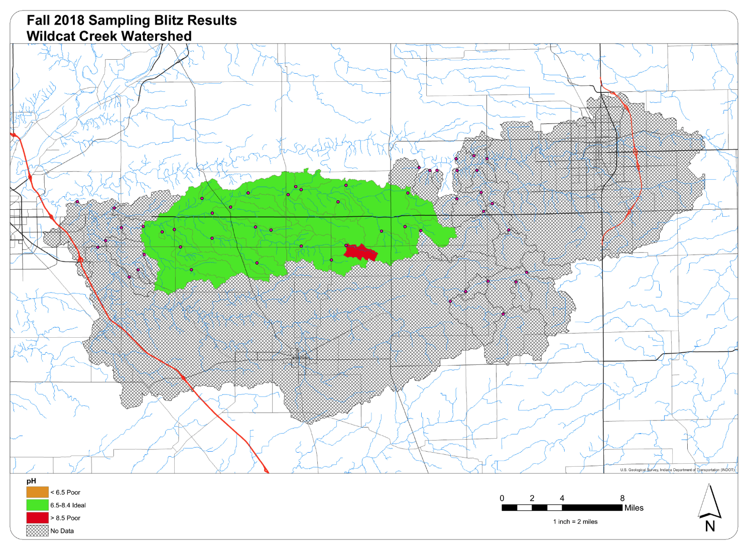
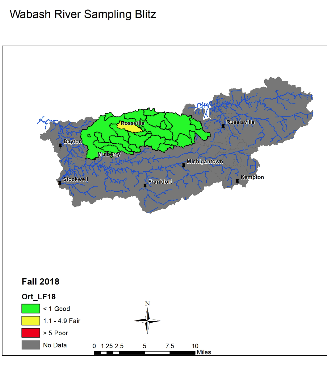
E. coli – E. coli is an indicator organism used to monitor pathogen concentrations with surface waters. E. coli is present in the intestines of all warm-blooded mammals and can survive and reproduce outside of the body. Untreated sewage, combined sewer overflows, polluted discharges, input from animals, and source populations can all contribute E. coli to surface waters. In Indiana, concentrations measuring greater than 235 colonies/100 mL are deemed non-supporting of their designated use. Those watersheds which do not meet water quality standards are shown in red. 

Map of the watershed with alkalinity readings represented by color.

Alkalinity – Samplers measured alkalinity from water samples at the staging location. Alkalinity and hardness also reflect the geological materials present in the drainage area. Alkalinity is a measurement of the base concentration in water. Nitrates, dissolved ammonia, orthophosphate, silicate, and hydroxides all generate higher alkalinity concentrations. As with pH, darker colors indicate higher alkalinity concentrations, while lighter colors reflect lower alkalinity concentrations. It should be noted that the preponderance of dark (>250 ppm) subwatersheds suggests that the test strips used did not have a high enough detection value.

Map of the watershed with hardness readings represented by color.

Hardness – Samplers measured hardness from water samples at the staging location. Hardness is a measure of the mineral content including calcium and magnesium present in surface water. Hardness measurements less than 200 represent slightly hard water, while hardness measuring higher than 300 is considered hard water. Like alkalinity measurements, the predominance of dark subwatersheds suggests that the test strips did not contain a high enough detection level to correctly measure hardness in our watershed.